Description
The pilgrimage leads from Maria Neustift (613 m) northeast to the Lower Austria border and over Bischhofberg (751 m) to the "Black Kuchl." Continuing over Haunoldstein and Bichl to Konradsheim (651 m, briefly steep uphill). From the parish church Konradsheim – here there is the possibility to stay overnight at the Seisenbacher inn – the path takes us to Haid (wayside shrine), then briefly uphill and then steeply downhill to Waidhofen (362 m). From the Upper Town Square, Ybbstor, Ybbsitzer Street to Florianibrücke to the Ybbs, on Arzberg Street (marking 06) on an asphalt road to the Schilcher farmstead (562 m), further to the municipal border Ybbsitz (about 3 hrs from Waidhofen/Ybbs) and via the panoramic high trail over Kleineck (631 m), Großeck, Oberriegl (612 m), Zwirch, to Ybbsitz (414 m).
Starting point of the tour
Maria Neustift
Destination point of the tour
Ybbsitz
Route description Upper Austria Mariazell Trail: B: 4th stage: Maria Neustift - Waidhofen/Ybbs - Ybbsitz
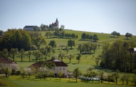
There is an interesting legend regarding the origin of the pilgrimage basilica in Maria Neustift: Allegedly, in the area around today's Neustift, two feuding brothers (Lord von Gleiß near Sonntagberg and Lord von Hartweigstein from the Hinterhaus castle near Ertl) met in battle. Shortly before the supposed defeat of the latter, he vowed to build a church if he survived. Suddenly fog rose and Lord von Hartweigstein managed to escape, whereupon shortly after the foundation stone was laid for the church. From this historic site, we walk northeast to Freithofberg and shortly thereafter turn onto a field path. The path leads through fenced pastures, we cross a stream and walk across the meadow to the next farm. Here we meet again on the road at a pretty orchard avenue and then hike from farm to farm through the green Mostviertel, enjoying wonderful views to the valley and surrounding mountains to the south, e.g., Elmkogel (898m), Spindeleben (1066m), Redtenberg (1028m), and Schnabelberg (958m). After a longer hike, we finally reach Konradsheim, which can be seen from afar by the distinctive hill on which the church of the small village was built. To Haid, the path goes again over meadows and fields, and it is quite possible to encounter peacefully grazing deer that do not seem afraid of pilgrims on this idyllic path. To the right, we can already see the Buchenberg, where the nature park of the same name is located. Shortly after, we come to a large chapel built on a hill and from there already have a wonderful view of the medieval town of Waidhofen. The cityscape is shaped by impressive watchtowers, baroque churches, and Rothschild Castle. We cross the town and leave it via Arzberg Street, walking uphill on a narrow, lightly used road. We come to two lovely rest places - one under a mighty willow, one at a chapel - and enjoy a wonderful view of Windhag. Through the hilly landscape of the Mostviertel, we pilgrimage from farm to farm and chapel to chapel. From the last hill (at a chapel above Ybbsitz), we have a fantastic panoramic view of the Prochenberg (1123m) and the Maisberg (942m), as well as the valley village Ybbsitz. The so-called Ybbsitz smithing center is particularly known for its artistic metal designs and traditional smithing craft. Throughout the village, we discover interesting sculptures, old machines, smithies, and other signs of the old craft. In 2010, "Smithing in Ybbsitz" was even included in the list of intangible cultural heritage of Austria.
Directions
Coming from Salzburg, it is best to take the A1 to the Sattledt exit. Then take the B122 to Steyr and drive to Maria Neustift.
Coming from Vienna, take the Amstetten-West exit and stay on the B121 until you reach Böhlerwerk. In Böhlerwerk, turn right and follow the L6195 and L86 to Maria Neustift.
Parking
There are many free parking options around the church in Maria Neustift.
From Steyr, bus No. 441 runs towards Großraming Ennsbrücke. Stop: Maria Neustift, town center.


