Description
As a former monastery, the Gaming Charterhouse is the largest complex of its kind in Central Europe and offers a beautiful view from the hiking trail. On the way over the Calvary, you pass 14 baroque Stations of the Cross.
Starting point of the tour
Kartause Gaming
Route description Gaminger Rundwanderweg
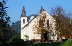
From the parking lot, the trail runs alongside Federal Highway 25, past the Carthusian monastery and the former monks’ cells. It crosses Highway 25 and the Mitteraubach stream and leads up to Kalvarienberg. From here, continue uphill to the Kalvarienberg Chapel. Shortly afterward, you’ll reach the highest point at Mitterberg. From here, the trail leads downhill and soon joins Mitterbergstraße. Turn left and continue down the road toward the valley until you reach the right-hand turn into Höllgraben. Walk through the forest along the stream, across a meadow to the road maintenance depot, and onto Schleierfallstraße. Walking time so far: approx. 1 hour. Turn left at the road maintenance depot and, immediately afterward, turn right at the Großgaming house, heading uphill across meadows into the forest toward Schwarzenbergstraße (turn-off to the Gföhleralm). Turn left onto the forest road; after about 3/4 hour, you’ll reach the Filzmoossattel, cross the state highway, and continue on the gently ascending forest road toward Hofsattel. Finally, turn left and walk through the forest to the Kirchstein above the town center. From the Kirchstein, head toward Kienberg to the B 25 at the “Maut.” Walk a short distance along the federal highway to the Aigner furniture store, turn right, and cross the Ybbstalbahn railroad tracks toward Griesselreith. Now head uphill on the forest road, then turn left onto the hiking trail along the Zürner stream until you reach Zürnerstraße at the Kartause and continue to the B 25.
Directions
A1, Ybbs/Donau exit—head toward Eisenstraße—take the B 25 to Gaming—The parking lot at the Kartause is located about 500 meters south of the town center on the B 25.
Parking
Kartause Gaming
VOR and Postbus routes stop in front of the Kartause. For schedule information: www.vor.at
T +43 810/222324
Verbund Line, www.verbundlinie.at