Description
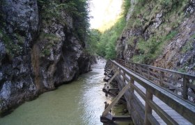
A small journey into the past and back. From Göstling, it initially goes 7 km gently uphill to Lassing, the start/end point of the Mendling Valley experience world. With a short but very steep (16%) climb, you turn towards Hollenstein; the following descent leads to the other start/end point of the 3.5 km long, romantically wild gorge along a stream. Here, you find one of the last functional log rafting facilities in Central Europe.
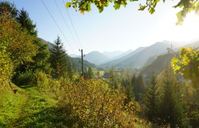
Past it, you go on a narrow road up to Promau (about 4 km, max. 8%), where a nice rest area with views of Gamsstein and Königsberg invites you to linger. The following 10 km lead downhill (max. 8%) through the Sandgraben as you approach civilization again, reaching Hollenstein on the Ybbs with its famous river beach bath.
Past this, you go upstream along the Ybbstalradweg through beautiful nature along the river and via St. Georgen and Kogelsbach back to Göstling.
Starting point of the tour
Göstling, town center
Destination point of the tour
Göstling, town center
Route description At the Holzweg
From Göstling, leave the town heading south and follow the Erlauftalstraße to Lassing. Opposite the small village, turn half right towards Lassing and climb the short, steep ascent into the Mendling Valley. It goes equally steeply down on the other side before the road becomes narrower but less steep towards Promau. In several bends, it goes uphill for about 4 km to the Promau height, followed by a 10 km long descent (initially steeper, later only moderately descending) to Hollenstein.
Through the village and over the bridge to the other side of the Ybbs, switch to the Ybbstalradweg and follow it back to Göstling.
Directions
Motorway exit Ybbs - Erlauftal federal road B25 to Göstling or B31 Ybbstal federal road
Parking
Göstling town center on the Ybbs
With rental bike: VOR bus line to/from Göstling. Bike rental Sportwerk in Göstling/Ybbs
With own bike: Radtramper or bike taxi to/from Waidhofen/Ybbs or Göstling
