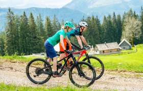
Details for: Sonnbrand-Almtour Göstling/Ybbs
Brief description
Attractive circular route from Göstling via Promau to the (half) Königsberg and back to Göstling.
Description
From the center of Göstling, you first leave the town on asphalt towards Lassing. Soon you leave the road and turn right where the first elevation meters follow - initially on asphalt, later on gravel/dirt paths. After a short descent, you reach Promau near the Mendling valley, from where a short gravel descent leads further uphill on and along the Königsberg. At Garnstatt, the route turns right and goes back to Göstling via a forest road.
Starting point of the tour
Göstling, municipality
Destination point of the tour
Göstling, municipality
Author's tip
If you have enough time, a detour including elevation gain to the Siebenhütte is worthwhile.


