Details for: Village circular trail "Nature.Enjoyment.Mountain" in the hiking village Hollenstein/Ybbs
Brief description
Circular hike from and to the central hiking start point via Treffengut Hammer and Kalvarienberg
Description
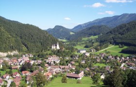
The route starts at the central hiking start point of the hiking village Hollenstein/Ybbs. The loop then leads from the village towards Treffengut Hammer. On the way there, a breathtaking view of the village church and the Kalvarienberg opens up. Towards Treffengut Hammer, the notorious Gamsstein and the Voralpe appear impressively. The rest area at Treffengut Hammer invites you to enjoy this view. After crossing the bridge over the Hammerbach, it goes back towards the church, where some historically valuable houses await. The short climb up to the church is rewarded with a breathtaking view of the Voralpe. Historical structures can also be viewed there. On the way from the church via the Kalvarienberg back to the central hiking start point, some historical highlights await, such as the oldest house of the hiking village Hollenstein/Ybbs.
Starting point of the tour
Municipal office and hiking start point hiking village Hollenstein/Ybbs
Destination point of the tour
Municipal office and hiking start point hiking village Hollenstein/Ybbs
Directions
From Vienna, take the A1 to the Amstetten-West exit, continue via B121 to Waidhofen an der Ybbs, from there continue on B31 to Hollenstein an der Ybbs.
From the west, take the A1 to the Oed exit, via Aschbach on B121, continue on B121 to Waidhofen an der Ybbs, from there continue on B31 to Hollenstein an der Ybbs.
Parking
Parking spaces available at the municipal office of the hiking village Hollenstein/Ybbs.
VOR bus line to Hollenstein/Ybbs town centre
Author's tip
⛰️ TIP: SHORT VACATION IN THE MOSTVIERTEL ⛰️
To get to know the hiking village Hollenstein/Ybbs, a short vacation is recommended. We are happy to help you with the booking:
info@mostviertel.at
+43 7482 204 44


