Kripperlweg

Hiking route from Hollenstein, Kripper Parking Lot

To view this content, you need to accept our Cookies. Change Cookie Settings
Full screen mode
Elevation profile

1,64 km length

Tour dates
  • Difficulty: Easy
  • Route: 1,64 km
  • Ascent: 44 egm
  • Descent: 44 egm
  • Duration: 0:30 h
  • Lowest point: 457 m
  • Highest point:478 m
Features
  • Round tour
  • Accessibility by train and bus
  • Suitable for families and children

Details for: Kripperlweg

Brief description

Easily accessible barrier-free hiking trail

Description

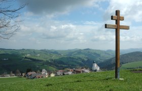
Kripperl parking lot - village square - parish church - school - rock crib - school - kindergarten - Kalvarienberg - village square - Kripperl parking lot

Starting point of the tour

Hollenstein, Kripper Parking Lot

Route description Kripperlweg

From the Kripperl parking lot, follow the signs across the romantically lit village square to the rock nativity scene. Some of the houses have very old wooden nativity scenes on display in their windows, and artfully painted figures line the path to the rock nativity scene and back to the Kripperl parking lot.

Directions

Coming from Vienna, take the A1 to the Amstetten West exit, then take the B121 to Waidhofen an der Ybbs; from there, continue on the B31 to Hollenstein an der Ybbs.
Coming from the west, take the A1 to the Oed exit, then head through Aschbach Markt onto the B121, continue on the B121 to Waidhofen an der Ybbs, and from there continue on the B31 to Hollenstein an der Ybbs.

Parking

Municipal Parking Lot

VOR bus route to Hollenstein/Ybbs

Author's tip

Swimming at one of the most beautiful river beaches on the Ybbs

More tours around the starting point