Description
Bizarre rock formations and soft dark green moss areas await hikers on the just over three-kilometer-long gorge hiking trail in Opponitz. The start and end point is at the Schluchtenhütte, just a few minutes from the Ybbstal federal road B31 and the new Ybbstal bike path. In this area spared from mass tourism, nature reveals its most beautiful diversity. The circular walk in the fresh mountain air is a treat for body and mind. At the Schluchtenhütte at the "Oberdippelreith" farmhouse, exquisite traditional delicacies and cooling drinks await. Children have the opportunity to get to know numerous domestic animals, which can extend the walking time accordingly!
Starting point of the tour
Schluchtenhütte at the "Oberdippelreith" farmhouse
Destination point of the tour
Schluchtenhütte at the "Oberdippelreith" farmhouse
Route description Opponitz Gorge Hiking Trail
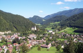
From the Schluchtenhütte, families hike up a forest road and continue on a meadow path until the beginning of the gorge path. First, hikers pass the "Hexenschlucht" (Witches' Gorge), then continue to the "Weihkesselmauer" and then up to the "Ochsenlucka." Via switchbacks, they reach the "Krokodilsfelsen" (Crocodile Rock) and the "Leofererstein," the highest point of the circular hiking route. From there, hikers enjoy a magnificent view of the surrounding mountain landscape and the town of Opponitz. After resting at the summit cross, the route continues past the "Sauschädelfelsen" (Boar Skull Rock) to the "Bärenhöhle" (Bear Cave). Along the "Teufelssteig" (Devil's Trail), where the very brave can abseil, hikers follow the creek past a pond back to the Schluchtenhütte.
Trail markings: signposting with humorous motifs
Directions
From Vienna or Linz via West Motorway A1 - exit Amstetten - Waidhofen an der Ybbs - Opponitz
Parking
Parking at the Schluchtenhütte


